It appears as if the the heat pump high will slowly migrate and build northeast ushering into PA another bout of unseasonably hot weather for early summer. The high tide of this heat slosh will be Thursday when temps should easily surpass 90ºF and possibly hit the mid 90s for max temps. The map below shows the GFS ensembles as a 7 day mean max temp vs the "normal" temps for the same 7 day period. Clearly, the northeast is modeled to be much above normal while the northern plains and the Rockies are guided to be much below normal.
However, by next Tuesday, it appears that cooler air will invade the US squashing the heat ridge farther south and west and allowing the northeast to cool off back to near normal temps.
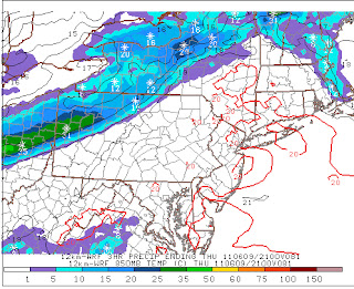
With Thursday likely to be the hottest day of the week with a max of 95ºF or so, a front pressing from the northwest could get a bit lively. It is not out of the question for storms to boil up any time Tuesday or Wednesday afternoon, however, it appears with the cold front moving southeast, focused convection will occurred Thursday afternoon into early Friday when the front clears the state. The map below depicts the 850 mb temps with the advancing front over the nw portion of PA Thursday afternoon.
The surface map for Saturday morning, should it verify, will deliver another gorgeous day for PA and points north bathing in much cooler and drier Canadian air thanks to that large blue H over southeast O Canada.
I'm still watching for Arlene to develop in the Caribbean and the Hurricane Center in Miami has upgraded the likelihood of the cloud mass shown below to become a tropical named stormed within the next 48 hours. You can clearly see the circulation of the deep convection just a bit east of where it was this weekend.
I feel a bit out of the weather loop due to a busy weekend that included nocturnal thunderstorms, surprising midday mesoscale convective systems, in depth research & discussions of the Illinois River Watershed, the significance of significant figures, seized horizontal wind generators, illegal athletic high school transfers, and a tiny strike zone by #55 Angel Hernandez in the Phils-Pirates game at PNC Park on Sunday. If anyone has the command to question a tiny strike zone, Roy Halliday has the credentials to do so. Eddie Gaedel would have had no prayer with Halliday pitching since that was the size of the strike zone Roy was successfully dealing with thanks to umpire Hernandez. Just unreal....and today, my voice is still a tad raspy due to my displeasure with his Gaedel-like strike zone for our boy Roy!
Enjoy your graduation ceremonies!
Smitty
AA: Warm becoming hot week with the peak of the heat Thursday. Cold front will pass through Thursday afternoon and evening giving us a beautiful Friday and Saturday and even Sunday I do believe.


No comments:
Post a Comment