Smitty's attempt to educate and to a much lesser extent, entertain, about all facets of life; but primarily the meteorological and the climatological aspects of the earth sciences.
That is what will describe our weather for the next several days. We are experiencing a classic case of Indian Summer. I know, I know, you need a frost before you have a spell of true Indian Summer. But many places this past week had light frost in the lower Susquehanna Valley. Under cloud free skies and light winds, radiational cooling was optimal. Consequently, very cool mornings greeted early risers and patches of frost were observed by yours truly. So I am calling this weekend's wx official Indian Summer! Here is the IR satellite image as of this early Saturday morning. Look at the expansive area of cloudless skies over the eastern part of North America.
And here is the 500 mb chart for the above observation. A sprawling area of high pressure at all levels is what is dominating our present weather. We waited all September to experience this fabulous fall wx! Note the 588 mb high pressure over the Ohio Valley. This will support daytime maxes in the 80s just to our SW and a few locations here in the lower Susquehanna Valley will also tickle the 80ºF mark over the next few days! The stormy weather is being kept at bay out in the Rockies.
But then by next weekend, the expansive ridge will break down and a closed upper low will have our wx deteriorate rather abruptly with the potential of once again copious amounts of rain accompanied with wind and raw conditions. This upper low will spawn a surface low that depending on its track will determine the exact location of the heaviest rainfall. Here is the 500 mb prog for next Friday. That is a broad deep trough over the eastern half of the US. The Landis drainage project may quickly get tested!
Here is the potential rainfall as depicted by the GFS for the next 8 days in the SE portion of the USA. Now some will say that is spitting out only an inch of rain over eastern PA. I know! But my fear is that heavy purple and red band which is far to the east may actually be corrected westward with time and that the heavy axis of rainfall is much closer to the coast. There is a potential sub-tropical system to develop by Tuesday off the SE coast and it may stay closer to the mainland than the present numerical predictions from the GFS.
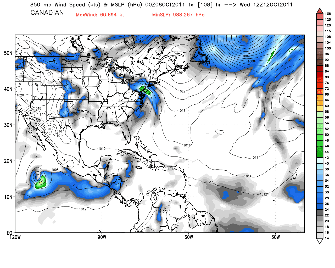
Here is the Canadian's depiction of this system. The first map shows tropical development by Monday. The 2nd is for Wednesday and clearly develops a rainy scenario for the middle of next week with a 1004 mb low over the Chesapeake Bay. So the jury is clearly still out! Not sure which yet to believe.
Here is the storm over the Bay.....albeit it not too strong...but that 850 mb wind from the SE would lead to much rain for our area mid to late week.
After this system passes on by, it does appear that much cooler air will once again invade the eastern US as shown by the 850 mb temps for next Sunday. And although I cannot show you, the 15 day prog is for an even deeper shot of cold air that will make many of aware that winter is just around the corner!
In closing, I would be remiss to not mention the total collapse of my favorite baseball team this October. The team was assembled (with outstanding pitchers) to not only win a short playoff series, but to win a 7 game postseason series as well! The only problem with the plan...you've got to hit! Manufacture a run...anything. When you give up ONE RUN in a deciding game, you should WIN! ONE RUN! That's it! ONE! When Chase Utley drove his ninth inning at bat 400'+ to dead center, I had the excitement of 988 mb low coming up the coast in January with a large dome of high pressure over the NE US....a classic nor'easter on the way! When his blast was caught by the Cardinal center fielder, it was like the storm veered off to the east and we got but a thin veil of cirrus from what turned into a "fish" snowstorm. The wind just left my sails....uuugh! Now we wait and see who will prevail for this year's version of October MLB! Not sure who will succeed in that venture either...
Have a good week's end!
Smitty
AA: Beautiful weather through Tuesday, then potential for some good rainfall....followed by another shot of fairly cool October wx! Now the Phillies can play golf with their RedSox colleagues!
...we are looking at yet another potential visitor from the tropics. Here is the GFS at 192 hours from now (middle of next week). That 996 mb low is tropical in origin and is taking a path similar to Irene if this model would verify! It is waaaay too far however to be definitive at this time.
And then looking far into the future, it appears the modeling wants to make the last part of October cold as the 850 mb freezing line dives into the deep south at day 15! That is one deep trough, again if that would verify. Just a heads up to all of this....
"With a load of iron ore twenty-six thousand tons more than the Edmund Fitzgerald weighed empty, that good ship and true was a bone to be chewed when the "Gales of November" came early." So sings the legendary singer-songwriter Gordon Lightfoot in his eloquent recalling of the sinking of the iron-ore ship that ran across Lake Superior from Duluth, MN to northern Wisconsin and the upper peninsula of Michigan. Most, if not all of you are familiar with this very famous ballad.
So why do I open with this? Well, we are presently experiencing November-like weather here in PA thanks to a very strong and digging trough at all levels of the atmosphere that did cause Storm Warnings to be posted earlier in the week over both Lakes Michigan and Superior. This morning's raw weather is a result of this anomalous low for this time of year. Take a look at the 7:00 am obs from across central PA!
CENTRAL PENNSYLVANIA
CITY SKY/WX TMP DP RH WIND PRES REMARKS BRADFORD LGT SNOW 33 31 92 NW7 29.85S FOG DUBOIS LGT SNOW 34 34 100 NW8 29.87R FOG CLEARFIELD LGT RAIN 37 34 87 NW3 29.86R JOHNSTOWN FLURRIES 34 34 100 NW16 29.85S ALTOONA RAIN 38 34 85 NW10 29.85R FOG STATE COLLEGE RAIN 37 36 93 CALM 29.84R WILLIAMSPORT LGT RAIN 42 39 89 W9 29.80R SELINSGROVE RAIN 41 39 93 W5 29.81S FOG FT INDIANTOWN CLOUDY 41 41 100 NW15G25 29.75F CAPITAL CITY LGT RAIN 42 38 85 NW12G22 29.79S HARRISBURG CLOUDY 42 39 89 NW15 29.78S YORK CLOUDY 43 39 87 NW8 29.79R
And read the statement from the State College NWS office this am!
0.7 INCHES OF SNOWFALL HAS BEEN REPORTED BY THE CO-OP OBSERVER AT LAUREL SUMMIT THIS MORNING. THIS MARKS THE EARLIEST DATE IN THE COOL SEASON THAT LAUREL SUMMIT HAS SEEN SNOW. CO-OPERATIVE WEATHER OBSERVATIONS HAVE BEEN TAKEN AT LAUREL SUMMIT SINCE 1997. BOTH KJST AND KBFD ARE SNOWING AS OF 11Z. TEMPS AT 34F MEAN LITTLE ACCUMULATION IS MOST LIKELY OCCURRING THERE...BUT THE HIGHER ELEVATIONS ARE MOST LIKELY AOB FZG. SUFFICE IT TO SAY THAT SLUSHY ACCUMS ARE OCCURRING ON THE RIDGE TOPS.
This is due to global warming as I'm sure you are all very much aware! Take a look at the model initialization for the GFS as this early morning....what a deep 500 mb trough and vorticity!
And you can clearly see the cold air at 18,000 feet streaming into the Mid-Atlantic states from O Canada. And you can also see that this low is once again too far south of the main portion of the jet stream which is displaced well to the north. Thus, until this upper low fills and and lifts northeast, we will have the potential for showers (instability) at any time, but the precip rates will not be too hard to handle. Look at the temps at one mile up as of this morning! Now this is not an observation; however, it is just run run from the initialization data at 06Z. Also note the very warm air aloft over MT, ND and SD. Under that 500 mb ridge, temps will moderate as that ridge progresses east during the week.
Here is a map of that ridge as forecasted by the GFS by Thursday afternoon.
The flow at 18,000' will still be NW, but the source region of the air has changed drastically. Thus, look for temps to moderate to a more typical early fall "norm". Here are the official NWS forecast highs for later this week (Friday).
So get through this "ugly" wx the next couple of days and early fall weather will be your reward awaiting your upcoming weekend! And here is another reward as you read to this point. A recording of the classic Gordon Lightfoot ballad of the Edmund Fitzgerald. He opened with this song on his second set last evening at the Luhr's Center on the campus of Shippensburg University playing with the same? 12 string. Gordon sounded like he was 72 yrs old and on his 18th show of his current tour. I felt quite comfortable walking into to witness this show since Doc had easily handled the Cards by setting down 21 straight after giving up that 3 run dinger to Berkman. Here's hoping that Cliff can work similar magic this evening at the Bank! Now kick back, relax, and enjoy this 6 minute ballad that described the fate of this ore carrying ship on that November day in 1975.
Enjoy your Sunday!
Smitty
AA: Quite raw and ugly for this time of year. But improving conditions will begin Tuesday with beautiful early fall weather by the weekend! Enjoy this folk song you "folksy" guy!
Make no bones about it, today will be ugly weatherwise. November will pay us a visit in the form of dark, cloudy, damp, & dreary weather as an upper level low once again influences our sensible weather through the weekend. This upper low is about as "low of a height field" as you see here in the early fall! 540 Dm is roughly the rain snow line in the winter used to determine precip types in these parts. Look at the upper low over the northeast this weekend!
Not only do we have that digging trough with which to contend, we also have a direct discharge over cold air directly from Hudson Bay aimed at western PA and WV. The 850 mb temps are progged to be below freezing for much of this weekend. This translates to surface temps easily being ~15º-20ºF below normal! Snowflakes should be spotted in the higher elevations of WV, VA, and NC this weekend. I wouldn't be surprised to even see the highest mountains of the Laurel Highlands in Somerset County, PA and Garrett County, MD see brief bursts to make the ground white from time to time. Wow! That is one ugly 850 mb map for this time of year.
Couple the cold air aloft with the vorticity from the 500 mb level, and we should see a rather ominous storm once again spin up, this time to our east. As a result, some backside rainfall is likely as shown by the surface map of the NAM seen below for Sunday morning. If that storm is a bit further east, the deformation precip will be directly over the Susq. Valley again allowing for yet another inch or so of rain to fall by Monday! Unreal!
It will not be until Tuesday or Wednesday once again until this upper level feature pulls away allowing for moderating temps and drying. I'm not too certain that an inch of rain will fall, but the potential is there. Here is the GFS take on the precip through Monday. As you can see, the "hot-spot" for precip is western PA. If the surface low is just a bit further east, wet will rule with heavier rainfall through Monday here as well.
But mid-late week next week will feature finally some nice fall weather as a large 1036 mb high will crest over NY and take control of the eastern US as shown by the GFS below. Also note the warming to our west at the 850 mb level meaning a moderating temperature will be in store for later in the week. You can also see 2 tropical systems in the Atlantic; Ophelia's remnants in the maritimes and the new boy Phillipe approaching and swinging east of Bermuda.
In closing, I'm not sure where to start. Remember, I love October sports and weather. Well, I love weather all months. Come to think of it, I like sports all months too. Just some better than others! I could address the 9-0 shellacking of Texas by Tampa Bay holding Texas to only 2 hits by pitchers I'm not even sure who they are! Or how the rain has once again interrupted the MLB schedule by wasting 2 outstanding pitchers from game 1 in the NYY-DET series. Also, I could espouse my hopes of Doc re-working some post season magic this afternoon. But I must report on what was a complete and thorough woodshed whipping by the CD Rams football team over its sister school. CD dominated all facets of the game; special teams, run defense, run offense, discipline of only 3 penalties I believe, turnovers...you get the picture. I guess if I could find any fault with the Rams, it was with the defensive play at the conclusion of the 2nd quarter when once again, the blitzing aggressive defense morphed into a "prevent" drop into coverage defense and East scored rather easily on a 6 play drive in ~1:00 minute. Other than that brief hope, the game was decided...arguably with 11:46 remaining in the 1st quarter! With the opening kickoff, CD returned the rock 98 yards to pay dirt and ignited a solid team effort throughout the game. East flashed some optimism throughout, but clearly...and I do mean clearly, CD was the far better team. Some renown local media mentioned that CD and CV are most likely the top 2 teams in District 3. Now I haven't see all of the teams play yet, but I can say that was a complete effort on the the part of the well coached Rams and next week's battle with CV should be a classic. East must regroup, understand they lost to one of the best teams in the District 3, and move on with their quest for the playoffs. There is an old adage in football: "You're never as good as the score implies and you're never as bad as the score implies". Well, CD looked impressive in the 49-7 win as witnessed by 7,000+ at Landis last evening. But I do not think East is as bad as that score indicates either. I believe there may be scheduling conflicts for Landis the 1st and possibly even the second round of playoffs as both CD and East will be extending their football seasons this year.
Have a great November-like weekend!
Smitty
AA: Cold and damp through Monday with slow improvement. Not great hunting weather due to winds. By end of the upcoming week, should be enjoying some nice fall weather. CD dominated East last evening...wasn't even close!
A very quick post concerning the kickoff weather for our games this evening. The first map below is the temperature map. The temp should be near 60F at kickoff, but will fall quickly during the game and by the end, the temps should be closer to 50F.
And the winds will be subsiding with the setting sun. The atmosphere will not be completely calm, but after a rather breezy day, the winds will actually be light. The wind direction will be from the west or blowing across the field towards the press box at Landis. If wind speeds are at 10 mph, I would be surprised. But again, at this time, I feel that the winds will not be too much of a factor.
As for the intra-district game, I call it a pick 'em. I believe that Red Land is far improved from the summer and Cedar Cliff is much better than its thrashing last week from Hershey! Now isn't that the politically correct call?!?
And come back again in moderation in, say, a fortnight. Just doesn't have that ring now does it? But it is the feelings of many in our area after this soggy and saturated September. KMDT recorded another 2/3 of an inch of liquid sunshine yesterday adding to both the monthly record total of 18.26" and the yearly record total of 61.65"! Unreal! The 14.97" previous September record was in 1975 and thanks to a similar pattern and Hurricane Eloise, flooding was prevalent then as well. Below is the track of Eloise in 75. She started as a classic African wave and tracked across the Atlantic until she unleashed her fury onto the the islands and then the US.
And here is the precip map as a result of Eloise and her remnants. Massive flooding occurred through the Appalachians and was a half billion dollar storm. Over 40 people lost their lives in the states due to her flash flooding, mostly in the Appalachians.
As for our present weather, let's start with the current water vapor image. I've placed some movements on there and I'll try to describe the current movements of the air masses involved.
Ultimately, the dry air from O Canada will win out (blue) but not until this entire upper low finally gets absorbed by the strong westerlies that are displaced to our north. The deepest moisture however has past (yellow) with yesterday's drenching thunderstorms. We could still see a shower on Thursday as another spoke of moisture will pass through midday (seen over Pittsburgh to Cleveland in above pic). But a stronger cold front will pass PA Friday as depicted by the official NWS map for Friday morning as seen below.
The large complex surface reflection of a low pressure over the Great Lakes and into Quebec will quickly accelerate NE as the jet pulls this complex finally away from our area! Friday will feature instability clouds and even a few brief showers or spritzes as a bona fide cold air mass advects SE and generates "Lake Effect" rain showers in the lee of the warm lakes. The temps a mile up will be below freezing on Saturday as shown in the map below.
Along with the much cooler temps, the dew points will be substantially lower as well. Here are the progged dew points for Friday evening. This clearly shows the surface air mass will have finally changed on brisk WNW winds! All of the deep moisture will be pushed out to sea and down to the deep south for the weekend, and quite likely until next spring!
In closing, what an unbelievable evening in MLB! The 2 greatest collapses in MLB in the final month of the season; the Red Sox blew a 9.0 game lead and the Braves blew an 8.5 game lead! And last evening, the Orioles win in a walk-off in 9....yes I said that correctly, the Orioles win! Then minutes later, Longoria from Tampa Bay strikes a low line (and I do mean low as it cleared that extremely low left field fence at the Trop) drive to culminate a 7-0 comeback to the the evil empire and walk-off into the playoffs 8-7! TB scored 6 in the 8th and 1 in the 9th to send the game into extras! Longoria capped the 8th with his 1st HR of the game, a 3 run shot to left center. As for the NL, the Phillies won an exciting extra inning game (13) mostly by some solid defensive play, and eliminated the Braves from postseason play. In doing so, the Phillies managed 102 wins this season, a team record and Charlie won his franchise record 645th win passing Gene Mauch! So now, the Phils vs Cardinals, the DBacks vs Brew-Crew, Rays vs Rangers, and the Tigers vs Yanks. Onto October, a glorious month in sports!
Enjoy your Thursday and Happy Rosh Hashanah for those who celebrate.
Smitty
AA: Finally getting the rain and humidity outta here! Friday will be a transition day to a much cooler and drier weekend. Wednesday was a great night in MLB. Red Sox prove that you cannot buy a World Series championship, let alone a spot in post season!
I do believe that Monday will be the last warm and humid day probably until next spring. I think we can crack 80 with high dew points Monday....it will most assuredly feel summery. The satellite below shows the streaming of moisture up into PA from the cut-off low over the Midwest and an old frontal boundary just off the east coast. The red shows this moisture advection and the blue shows the old frontal boundary. The black is what is waiting in the wings once this cut-off pulls away in the mid-week period.
The front will pass through on Tuesday giving us our last real threat of meaningful precip for awhile! The upcoming period after Tuesday will be decidedly drier. Oh, there will be some instability showers, but the pattern suggests a much drier time in the next 10 days!
This front will usher out the humid air that we will have in place now through Tuesday. Below shows the near 70 dew points in SE PA.
It will be gradual, but the cooling will come in spades by Friday afternoon as a secondary shot of cold air from O Canada comes down and actually creates some lake effect rain showers due to the very cold air aloft at ~5000 feet! Take a look at that diving trough!
The operational GFS is not as bullish as the Euro is as seen below. The GFS is on the right. The graphics below are for the upcoming weekend period. Both show the dip in the jet stream, but the Euro is much more pronounced!
The ensembles of the GFS, however, do agree with the deep trough. Remember, the ensembles are many models that are run at slightly different initialization. The operational is only one of the the models in the battery.
So that is why I believe summer's last real stand is the next couple of days. Thus the end of summer is now literally upon us as the autumnal equinox occurred last Friday. And seeing that it is September 25, not only the end of summer but 31 years ago, it was the end of Led Zeppelin due to the death of John Bohnam. It was a sad day in the world of Rock and Roll and for me as I had a ticket to go see Zep at the Pittsburgh Civic Arena in November. So I'll leave y'all with this classic!
Have a good Monday!
Smitty
AA: Summery the next couple of days then cooling down. Looks to be pretty chilly for this upcoming weekend!