Smitty's attempt to educate and to a much lesser extent, entertain, about all facets of life; but primarily the meteorological and the climatological aspects of the earth sciences.
Let's look at how the GFS has come around to the other global numerical modeling on this impending storm...which will be one for the record books across the Mid-Atlantic and northeast US! Here is the run from yesterday valid Monday morning...
Now for the same time but the model run 18 hours later...
Quite a difference in both the intensity of the storm and the positioning of the center of low pressure! Now here is yesterday's total precip for the event as per the GFS...
s you can see, it has the bulk of the precip falling out over the ocean with KMDT receiving ~0.50" rain. Now the same model 18 hours later...
Now we are close to 2.25" rain for the event...and what this graphic doesn't show is the wind and cold accompanying this storm! It will be a good night to stay in and watch Sunday night baseball...but I believe it will be a wash out seeing that it is at Fenway Park in Beantown! So then, maybe it would be a good night to brush up on your candidates running for office and prepping for Tuesday's primary! In either case, enjoy your Friday and to quote a sage I've met in my travels "Absolutely nothing will ruin my Friday"!
And enjoy your week's end! Remember, we NEED the rain!
Smitty
AA: Major rain event for the upcoming weekend with the bulk of the rain falling Sunday into Sunday night for us.
This is a very brief post updating y'all on the status of this impending nor'easter to affect the east coast of the US in the Saturday to Monday time frame. The prime time for storminess for us here near KMDT is late Saturday night into late Sunday night. The sensible weather for us will bring windswept rains and a with a few snowflakes thrown in for good measure, especially for those of you who live on the tops of the ridges just to the north of Harrisburg! This will be a more serious threat, I do believe, and very much similar to the October snowstorm, for those in the mountains of WV, PA, up into the Adirondacks and further on into northern New England. This could be one for the record books! Heavy wet snow will accumulate on the new foliage in the areas will snow will fall and downed trees and power lines will be an issue.
Here is the surface map as depicted by the Euro for Monday morning! Can you say an old fashioned nor'easter! In theory, places in the blue shading would be seeing some snow, but at this late stage of the season, this will be elevation dependant.
And here is the upper level support for such a storm. Look at the negatively tilted trough that spins up this 988 mb monster!
So Smitty, what will our weather be? The sensible wx should essentially be windswept rains for us flat-landers primarily on Sunday as we receive ~1.5-2.0" of liquid sunshine! And we sure could use this as both our groundwater and the river have been steadily in decline and are well below normal for this time of the year. Take a look at the Dauphin county Test Well located at the Gap since April 1...
And the Susky at Harrisburg during the same time period...the brownish triangles near the top of the graph indicate normal discharge! Wow!
In fact, the entire northeast could use the rain as indicated by this regional picture of surface stream flow...red is dry or below normal...
Gotta go...but before I leave y'all, how about this for a thought. Since I am accused for being so extreme all of the time with my weather interests and economic concerns, how about this call for the MLB season?!? The Phillies will end with a worse record than the Orioles and/or the Mets! I really believe that the Phillies lineup right now, although it is early, doesn't scare the 5th starter on the lowly San Diego Padres! And the Orioles are blacked out for me on MLB TV...now go figure that one!
Oh well....enjoy your weekend nor'easter!
Smitty
AA: Looking more and more like an historic weekend nor'easter will affect the east coast of the US!
Concerning this weekend's upcoming and impending strong east coast cyclone, I am siding with the foreigners on this one. Too many times the American modeling progresses systems too quickly and doesn't allow for a full fledged cyclogenesis to occur along the natural baroclinicity of the eastern seaboard. With the upper air features just now getting to the North American continent, I believe the GFS by the end of today will begin to spin up quite a doozy along the Mid-Atlantic coast and pummel the east coast with gale forced winds and copious amounts of rain late Saturday evening into early Monday morning. A storm of this intensity is rather rare for this late into the season, but most of the global modeling is suggesting just that.
Lets take a look....1st the GFS for Sunday...a front has passed through PA without any phasing and the storm develops too far off the coast...swing and a miss!
Here is the NAM...similar scenario with disjointed storm formation too far east to truly affect us here in PA.
Now onto the European...It shows a 996 mb low deepening off the Carolina coast with the upper level cold advecting rapidly into the storm as shown by the blue colors...
And here is the "bomb" it develops within 24 hours! Kaboom! This would give snows to northern PA up through the Adirondacks and into northern NE! For us, we'd be looking at wind swept rains totaling 1.5-2.5" by Monday morning.
Even the UKMET has the same potential...although I can only go out 72 hours for the modeling...
So time will tell, but I do believe the truth lies somewhere in between...that is why it is called guidance. The GFS is too dry and progressive while the extreme Euro is a bit too extreme...yes....even for me!
And speaking of extreme...10-3 final in a Stanley Cup playoff game! Wow! That's what happens when you think you can take a night off...or at least not give 100%! And out on the west coast, Cain and Lee pitch 19 scoreless innings, give up 9 hits, 1 BB, SO 11, and have nothing to show for it! I believe this might just be a precursor of things to come for the listless Phillies...oh well!
Have a good Thursday!
Smitty
AA: Nice through Saturday morning, increasing clouds by Sat evening with a few showers, but looking for a major wind driven rain event for Sunday! Cold to follow for a couple of days.....
Recently, I've had several comments from my faithful minions that I have been eerily quiet with my postings. Admittedly, I have not been as faithful to the Google blogger as I have been to the Cybex Arc Trainer! I have been however posting a few quick tweets from time to time to give those of you who follow my tweeting a quick "heads-up" as to what the wonderful world of weather might hold in store for us. And what it has up its sleeve for this weekend is the potential for a news-making storm for New England and northern NY in terms of a late season snowfall, and for us here in central PA, a nice cold soaking rain storm that will instantly make trees go full foliage and allow the grass to grow quicker than the East High girls 4x100m relay team moves their baton around the 400 m track! But before we go there, lets look at yesterday...here is a wx-gram for the temp and humidities...note the high temp was only 86F whereas the record high for the day was 89F. Yes, it was near record breaking heat, but the core of the hottest air actually moved "over the top" and was found in upstate NY and New England. We did spend several hours in the low to mid 80s yesterday which made it so summer-like for a mid-April Patriot Day.
However, during the early morning hours, an air mass front passed through PA and was ushered in on some rather gusty wind shift air movements. Take a look...note the wind shift from SW last evening to NW at this time.
And along with that comes much cooler air at all levels which creates the widespread cloudiness that we are experiencing Tuesday as seen on this visible satellite pic. There is also a minor little disturbance on the southern part of the front that will create some light precip just to the south of PA on Wednesday, but we should remain dry through Sunday.
As for us, high pressure will rule the roost until this anomalous storm spins up this weekend. Here you can see how the cooler and shall I even say drier air has made the air pressure rise over the last few hours and making for clear sailing through the skies of central PA with VFR wx across the state.
Now onto the weekend...here is a cursory glance at the 500 mb level with a phasing storm system, albeit not as deep as previous runs and showing signs of a more "positive" tilt to the trough axis as had been previously modeled by our numerical forecasters!
And the surface reflection of the upper air as seen below for the same time...
There is substantial agreement amongst the global numerical modeling as seen here with my usual favorite, the Euro. Take note to the position of the low pressure over northern FL. Both the GFS and ECMWF show very close cyclogenesis positions...pretty awesome...eh?
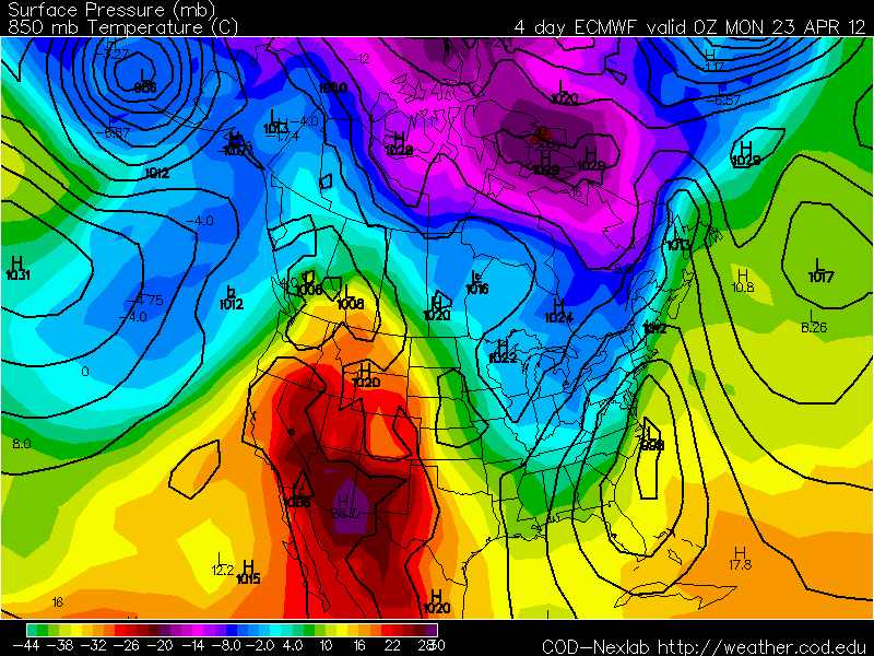
And a day later after the low races up the coast, cold air rushes in on the back side of the deepening gale center that will be pulling up into the maritimes of O Canada! Look at that early season heat building out in the deserts of the 4 corners...no wonder the ball carries so well at Chase Field in Phoenix! So early next week after a soaker of a Sunday, we are looking at some fairly cool wx for this time of year, but after all, it is late April and temperature swings should be the norm!
And speaking of "norm" and not so "norm", look at the outbreak of severe wx this past weekend and the number of tornadoes that were spawned by this front that just passed through here last night. Just 2 crazy days has our Tornado Total above normal...this is, in my opinion, a graphic that speaks volumes for severe wx...
And I know that the global warming crowd touts this extreme wx thanks to all of this phony baloney nonsense that you and me are solely responsible for causing this anomalous wx. Well, I wonder where these folks will be if the Japanese Numerical Climate Prediction (JMA) comes to fruition for this summer period of June, July, and August?
Heck, there might be some GW bridge jumping if this upcoming winter prediction from the JMA verifies!!??!! At the very least, maybe natural gas prices will rebound some? NatGas lowest in a decade! Wow! Maybe not after next winter...!
OK...gotta get to the foot doctor so he can work his magic and allow me to kick out caloric workouts on the cardio equipment. Some of you know how ugly my dogs (not Ziggy and Zola) are and at times they can get the better of me. However, the good doctor makes 'em feel like new for a quarter and its off to the races...as it might be for the sweeping Flyers. How about that? Now I know most of you don't really give a hoot about the NHL, but there is something special about the Stanley Cup run, especially when the team you're rooting on is doing well in the first round. Can only hope it continues if they get past those potentially pesky Penguins. Here is a nice retro glance at the Broad Street Bullies and Fred Shero's boys...Glory Days...
Hey, since the Phillies games out on the west coast are ending just an hour or two before I awaken, I change my focus to the boys of winter and spring...
Have a good week!
Smitty
AA: Near record heat Monday followed by dry and seasonable wx through the weekend. A major storm system looks to be impacting us primarily on Sunday giving about 1.50" rain across most of the eastern part of PA. Then a cool shot to follow and then once again becoming seasonal for the middle and latter part of the last full week of April. Here is next Saturday's temperature anomaly from the GFS. Slightly above normal...GW you know!
I've had a few people ask why I haven't put anything out lately...well with the start of high school spring sports, MLB, Easter, gardening, the gym, a couple of dogs, and my lovely wife, well, I've kinda been just a bit preoccupied! Well, here goes....
As for Wednesday, it will be the nastiest day of the next several...possibly the remainder of the spring! With a stiff wind (oh what a surprise there!) and cool-cold temps for mid April and the threat of showers at any time from noon-6pm, it will not be one of those pristine days we've become accustomed to over this past weekend! Here are the forecast temps for 4 pm this afternoon...I believe they are a bit too low, but the trend is to struggle to reach 50ºF by midday!
And with these coolish temps are the brisk winds...
And along with those winds and coolish temps will be the threat of showers. Now not everyone will see rain, but MOST will! In addition, we are not looking at a drought buster here...but any drops of liquid sunshine would be beneficial as we are now quite dry in the top layers of the earth!
But temps will gradually moderate and by Sunday, we are looking at temps during the max heating to be easily in the low to mid 70s...much above normal which is now in the low 60s...
At a quick cursory glance into next week, I do believe that severe weather will rear its ugly head around Tuesday in the Mississippi and Ohio Valleys as shown by this surface map. A strong cold front will be advancing eastward with strong dynamics thus severe wx should be occurring sometime in the Tuesday-Wednesday time frame just to the west of PA and some of those strong storms could encroach into PA as well! Here is the surface prog for next Tuesday with a vigorous cyclone over the Midwest!
I'll leave everyone with this...there was another major earthquake over in the Indian Ocean just off the coast of Sumatra making the Java Trench that much deeper I am sure...here is the preliminary data screenshot...8.6Mag is a major shake...wow!
Ok...gotta go and go play comet watcher and meteorite man for the next several hours!
Have a great Wednesday! Halladay vs Johnson or Shields vs Verlander or Strasburg vs Santana or Lester vs Romero....its nice they are spread all over the day...go pick your MLB poison! Oh yeah...go Flyers!
Smitty
AA: Ugly spring weather Wednesday moderating into a nice day for Pan-Ram and a quite warm Sunday with temps 15+ normal! Possibly some showers late Saturday night into Sunday as warm air moves in...could get nasty to our west next Tuesday and some storms could get here by Wednesday. Big quake over in Indonesia...which is east southeast of India!
Now that the skies have cleared from our 1" rain event, its time to take a quick peak at the skies just after sunset this evening and again tomorrow evening as there will be quite the celestial showing once again. Jupiter will be paired with the moon this Sunday evening and tomorrow Venus and the moon, the 2 brightest nighttime objects will be juxtaposed in the western sky. Venus is especially bright right now as it is located at maximum eastern elongation and positioned 46 degrees from ol' Sol! That means a good 3 hours of viewing pleasure of our globally warmed "sister" in the sky. Once facing the waxing crescent moon, turn about 90 degrees to your left and take notice to the mighty hunter gracing our southern sky. We are quickly losing our winter sky and the often familiar constellations that don our celestial dome at this time of the year.
It will most certainly feel more like winter as I do believe we will fall to freezing Monday night into Tuesday early morning with a frost being widespread upon the landscape at sunrise Tuesday. Here are the forecast lows for Tuesday morning...Brrrrr...
Here is a map of the accumulated precip from our rainfall Saturday. We did need this as the ground really soaked up the liquid sunshine. With the recent warmth, much of the vegetation began to awaken from its long winter slumber and the water was put to essential use. It's just a shame that it had to fall on the weekend, but it is what it is!
And it is a good thing that it did fall as it looks as if there will be minimal rainfall through this week. Temps will be much more in line with climatology this week; however, the dryness of recent weeks seems as if it wants to persist. This is a total of the modeled precip through April 1 or next Sunday!
With all of that said, have a good week weatherwise and otherwise. The high school spring sports season gets into full swing, MLB opens in Japan, the final four in the NCAA Tourney this upcoming weekend, and the final two weeks of the NHL regular season....along with countless concerns of airborne allergens! It must be spring!
Enjoy!
Smitty
AA: Good sky gazing this evening. Cold and blustery Monday. Frosty start Tuesday morning. Minimal rainfall this week. MLB Baseball starts in Japan for a 2 game series.
As the post title suggests, (and of which most of you are quite aware), we have just experienced a stint of record breaking warmth over the eastern part of the country. And, again as most are aware, rain is in the short term forecast. Lastly, back to reality for the last week of March. Let me expound on each "R".
Binghamton, NY just had a SEVEN day stretch of record warm temps as they topped out at 71ºF Friday afternoon. Keep in mind however, KBGM has on been keeping accurate wx data for 61 years. The media probably will not alert the public to that which makes that 7 day stretch not so impressive....but nonetheless, rather extraordinary! Pittsburgh, PA has not had max temps 70ºF or higher for TWELVE consecutive days! For the period from March 12 to March 23, that too is momentous! And our local KMDT did establish a new record max for Friday as the mercury climbed to 79ºF at 2 pm eclipsing the old record max of 78ºF established in 1938 and 1907! It most certainly felt summer-like and by analyzing the max temps below, it WAS summer-like on Friday! I have to post Thursday's maxes as the NWS has yet to update the climatology for March 23...since it is still March 22 in some parts of our country as I am typing this...But here is Thursday; still far-reaching and historic warmth for March 22! Take a look...
I found this graphic showing the high resolution of the heat that accompanied the heat of Thursday. Note the cold of the lakes, the persistent upper level low over the southern plains, the snow covered Cascades and the O Canadian Rockies, and why the SE flow this week kept KMDT coolish and foggy as the coastal Atlantic at our latitude is quite cold...awesome hi-res surface temp graphic!
The bubble of heat will get knocked down this weekend by 2 atmospheric features. The first is this bowling ball of an upper level low that is slowly moving SE from it present location. Here is the 500 mb analysis as of 0Z last evening...
By Sunday afternoon, note to where this upper level low has migrated...
The other factor that will send us back to reality is the strong diving vort max seen above just to the ESE of James Bay. This will allow for some rather chilly air aloft to advect towards the lakes and New England and graze eastern PA with some back to reality temps for Monday and Tuesday. Here are the 850 mb temps for later Monday...
Not to worry though mates as this trough of reality will quickly lift out 36 hours later...
But another shot of O Canada is coming towards the northern tier of states for the latter part of next week...
So most decidedly, back to reality in terms of temps for next week as well as rainfall, too. With these cool shots from our neighbors to the north, we will also have opportunity for some showers to accompany these frontal passages. But frankly, we could use some rain as I was tilling my garden yesterday and the soil was actually quite workable and even darst I say DRY for the cool crop planting! Unreal for March 23! Here is the 7 day running mean for the period ending next Sunday, April Fool's Day! Clearly, the heat has retrogressed westward and the trough of coolness has become established in the northeast US.
As for the short term and the rain, here is the current IR satellite of where the coldest clouds and deepest moisture are located.
And the current radar to boot...
As the upper level low moves to our south and east, these bands of showers will move across our area over the next 2 days. It could literally rain at anytime from daybreak Saturday until nightfall Sunday. I think the greatest likelihood of precip is Saturday afternoon into early Sunday morning. By Sunday evening, here is what the NAM believes for our total precip in the region. It appears that ~0.5" looks like a good bet, but lesser amounts if you miss one of the bands of rain or over an inch if a band gets 2U...not U2!...Sorry...I'm listening to music!
So there you have it...Reality, Rain, Records...all in one fell swoop! And speaking of U2, I'm not sure to what Bono was referring when he sang this tune, but I'm fairly certain he was not referring to our May-like wx in March! This opening song was performed by U2 on their tour last year. The below video clip is from La Plata, Argentina about one year ago! Enjoy!
Smitty
AA: The end of quite a spell of record warmth across the east, some showers this weekend, but not raining all of the time, and more typical early spring-like wx for next week! Have a great week's end my friend!