Smitty's attempt to educate and to a much lesser extent, entertain, about all facets of life; but primarily the meteorological and the climatological aspects of the earth sciences.
Just a quick update on the heat! I've attached the 3pm obs of the area around PA. Note the 103 F in Elmira. Also, the 101 F in Newark, NJ. That is the classic "hot spot" in the northeast USA. But the 103 in Elmira, and the other 100+ readings in southern NY show you what I often talk about of the heat "coming over the top" of the ridge. That heat will tend to migrate southward tomorrow and now I believe Friday will be the hottest day. You know it is hot outside when I have the central air set at 80 F and it feels quite comfortable in here! Man, it is crispy outside and we need some rain.....and it doesn't look good.
Here are 2 thermograms and their accompanying humidograms. Please remember that when the actual air temps exceeds 100 F, the dewpoints must come down in order for the parcel of air to gain that raw kinetic energy. It takes a tremendous amount of energy to keep water in the vapor state at normal surface air pressures, thus as the dew points lower then the air can gain more energy in terms of raw motion, i.e. heat! I don't want to bore y'all, but this is fascinating to me. Even though the wind "feels" good, it allows the temp to increase on days like this! If you hang your wet towels outside today, they will dry quickly even though the air is relatively speaking, humid. But it is so hot, hot, hot, that water just gains enough energy to jump into the air and into the vapor state. Neat.....isn't it?
By the time I got all of this done, the 4 pm obs came out. Check it out! I love extreme wx!
Here is 103 F Elmira's graph and the hot spot of the northeast Newark's graph as well.
Be careful when reading these as their axes can be confusing.
Enjoy the tunes....you might as well feel like you are in that Caribbean paradise....not that tropical PA or Madison Square Gardens, NY! (or Elmira, NY!)
Enjoy the heat all you lovers of this heat.....it's hot!
Smitty
AA: It's hot! Potential record heat today and Friday. We need to get to 101 F to tie, 102 F to break the record for KMDT!
And I'm not talking about the extreme heat that we in PA are going to experience Thursday and Friday. I know I really shouldn't editorialize about the weather, but the heat and the lack of rain has made this week not very enjoyable for those of us who dream of high temps in the 20s with snow covered ground. But seriously, one must exercise caution when experiencing 110 F heat indices. The coupled effects of both the heat and humidity will make the temp on the human body feel like 110 F! Just think if you had a coat on on top of that like our 4 legged friends. Below are 2 charts; one with temp vs dewpoints and the other with temps vs relative humidity.
We should have straight air temps near 100 F and dewpoints around 70-74 over the Thursday-Friday time frame in the afternoons. Those are "danger" zone heat indices.
The map below shows the models' depiction of the hottest temps for PA. This is for Friday afternoon when once again heat the heat index will approach 110F. This is about as hot as it can get around here as we live in a humid environment and the water vapor essentially puts a dampening effect on the air's temperature. The record high for both Thursday and Friday is 101F for Harrisburg. We will approach these levels and could possibly exceed these if and only if some dry air mixes down to the surface from aloft.
OK...so we all know it is hot. Relief is now being seen on the water vapor image seen below where I quickly sketched the boundary between the hot air over the plains and the east and the cool air to the Pacific west coast. While the mainstream media is hammering away at this heat wave, record cool temps have been prevalent across CA, OR, and WA. Just earlier this week, Bakersfield and Palm Springs, CA experienced record low max temps. Now I know upper 80s and low 90s is not that cool, but it is in the deserts of the SW in July! Note the air over PA has its origins in northern Mexico and SW Texas...ugh!
But relief in the form of the upper air flow will help give us a break from this current heat wave by Monday. Here is the upper air flow progged for Tuesday.
But this relief may be short lived as the US modeling is showing another resurgence of the heat by the following weekend. Here is the upper air flow for next Sunday. That is one big burly Bermuda High!
But it is not the weather that really has me sad. It's the end of the shuttle program that does. And just as Apollo ended, there was a new beginning in the planning of NASA. This time; not so much. The brain drain of the USA continues as we have no real plans for manned missions from our own resources. Instead, we will pay the Russians $60+ million just to get our astronauts to the space station. Regardless of what the political pundits or TV talking heads suggest, there is very little leadership in the country in many aspects INCLUDING THE VERY TOP! There has been a very successful and world envy space program during my entire life in the US. Now, this current administration would rather spend its resources in a vastly different manner than educate, train, and EMPLOY its brightest young people. In fact, I swear we strive for mediocrity in this country...what a shame! I doubt if we would ever hear as inspirational a speech from our current president as was given by another democrat and tremendous leader in the challenge thrown down as seen below!
Enjoy your hot Thursday-Saturday....and hang out in the shade sipping your favorite cold beverage.
Smitty
AA: Very hot and uncomfortable until Saturday...then slowly cooling through middle of next week. But more heat on tap for the following weekend. NASA's shuttle program is now mothballed after 30 outstanding years of scientific leadership in the USA!
That's what the lawns and fields of central PA are becoming! With the low humidity and the hot July sun, the lawns are now showing their stress in these hot and lack of rainfall days that have been numerous here in July (we are -1.18" to date for rain in the month of July). The heat has not been too abnormal, but this week we will have temps above 90ºF everyday except maybe Tuesday. I do believe that either Thursday or Friday we will hit 100ºF at KMDT, especially if meaningful rain does not fall in the interim. Below is a map of the forecast max temps for both Thursday and Friday. First Thursday...note the smattering of purple colors >100ºF just south of us. There could be some 100ºF readings in PA as well.
Here is Friday. Note the larger region of purple indicating a generally hotter day than Thursday. There is a possibility that clouds from thunderstorms may help cap the heat Friday, but nonetheless, we are looking at 2 awfully hot days with humidity to boot! But for those of you who are observant; note the large O Canada high looming in Manitoba and with it is relief that will gradually make it here by early next week.
Here is the upper air pattern for Sunday. The dip in the jet stream will allow for some moderation in the extreme heat, but real relief will not be felt until mid-week when a stronger vort max spins down from our neighbors to the north. Also note the center of the heat is now centered over the 4 corners...where it belongs quite frankly.
By next Thursday, the upper air should be diving into PA and points south...so relief will be both in terms of heat and potentially numerous opportunities for rain from the middle of next week on......that is one deep trough for this time of the year!
Here is the rainfall progged over the SE US for the next 8 days. It does appear that aside from a few showers and storms that may try to bubble up due to the intense heating of the low levels and try to boil up into the very warm air aloft (not easy to do!), there will be little chance for rainfall until the middle to end of next week. So keep those tomatoes wet! PA looks to receive less than an 1.0 inch of precip for the next week. Ouch! The areas to our south where the dead front will stall creates an area of weakness in the atmosphere and this boundary will serve as a focus for convection, but not for you!
My wife jokingly speaks of the "umbrella over Etters!" Well, last evening, the NWS from State College had my immediate area as many of your areas as well under a SEVERE THUNDERSTORM WARNING. Well, all the atmosphere could muster for us was a TRACE of rainfall....that's it! A trace! I'm sure some of you received a little more based off the radar returns...but a few small drops at that...these drops were puny. So be sure to keep those plants, especially new plantings, wet during this heat and get out there and do the rain dance to fight off Elaine's nemesis.
There is a tropical storm that may strengthen before it departs ENE away from the coast, but it will be of no help to bring rainfall to the mid-Atlantic states either. Here is the current satellite depiction of Bret. He's pretty wimpy....
In closing, it will be warm today and becoming hotter and more humid as the week progresses. The heat will peak Thursday and Friday. So get ready for some Lovin Spoonful weather although the country bumpkin seen below has no clue about the city even though the back of his redneck gets dirt and gritty!
Have a great week...it's most certainly a poolside week of weather!
Smitty
AA: Hot today and getting hotter (maybe 100ºF either Thursday or Friday around here!) with little chance of rain. Temps will finally fall below 90ºF for highs by Monday I do believe.
Clearly, Thursday was a perfect 10. Due to slightly warmer temperatures and dew points, and I do mean slightly, Friday will be a 9! The map below shows the Model Output Statistics (MOS) for the ensemble max temps for Friday from the 12Z run of Thursday's North American Model (NAM) and the Global Forecast System (GFS). First the NAM:
And the GFS:
As for the upcoming week, temps and humidity can only increase from these glorious July levels. Upon quick glance of the modeling for next week, we are looking at Tuesday-Thursday being the high tide of the heat and humidity. It will still be hot past Thursday, but the humidity may abate due to the NW flow in the mid-levels of the atmosphere. The graphic below shows the GFS ensembles for next Thursday. Note how many of the runs actually place the heat ridge right into PA which would lead to temps well into the 90s for us here in Harrisburg. I do think that either KMDT, KPHL, or KLNS will reach 100F next week. It does appear that NY and points further NE will escape once again the extreme heat and humidity that will try to bleed into the northeast with this monster middle America ridge.
With the ridge in this position, we could see some beneficial rainfall from a complex atmospheric phenomena known as a Mesoscale Convective System (MCS). I will talk further about those next week for those of you who have insomnia! This radar graphic is an MCS from 2 years ago. I simply include it to show you the severity and the scale of these most complex atmospheric phenomena.
OK....kind of an inside joke here, but one on which I must capitalize. Yesterday being a "10" and today progged to be a "9", I guess the sum total of these 2 days are "19"! So here you are silver tongue, my lone follower, just getting primed for Friday Night Lights! From their 1980 album Gaucho, here is Donald Fagen, and Walter Becker's classic hit. Nice! Sure looks good! Umm, Umm, Umm...
Enjoy your week's end!
Smitty
AA: Nice weather through the weekend...getting hotter and more humid reaching its peak next Thursday-Friday time period. We will have a real heat wave next week....I think....
For the middle of July, Thursday will be a perfect 10. Dew points will be in the low 50s with high temps in the low 80s under bright sunshine! It just doesn't get much nicer than what the weather conditions will be for Thursday....just splendid! The infrared cloud image below shows the vastness of dry air in our region.
Friday looks to be nearly equally as nice although there will be a few more clouds that dot the sky. The synoptic map below forecast for Friday morning shows that we owe our nice weather to this rather extensive area of high pressure centered over the northeast US and SE O Canada.
We will have a return of the heat and humidity very gradually, but even this weekend looks to be rather nice. The humidity will slowly increase by Sunday night and by early next week, the heat and humidity will return. The 500 mb prog for next Monday shows the big upper high building once again, this time a bit further north & east than this week. That means some warmer conditions will once again build into PA and really limit any chances of meaningful rainfall in the next 7-10 days! But note once again that PA is under NW flow at high levels which will suppress the greatest influx of humidity to PA and new England. But that is a classic heat signature for the central and eastern US. Ugh!
Here are the anomalies for next Thursday. Note the large deviations above normal in our the Great Lakes region. It looks like next week will be the hottest week of the year. We will have a heat wave with at least 4 days exceeding 90ºF. It looks like a stretch of hot and humid weather will invade PA beginning next Monday or Tuesday. That will not be a perfect 10!
Aaahh yes...."10". Do y'all remember that overhyped 1979 movie with Bo Derek and Dudley Moore? There was nothing 10 about it except for Bo! That what the movie was...it should've just been called Bo Derek....I guess it kinda was!
Enjoy these Perfect "10"s!
Smitty
AA: Nice weather through the weekend. Hot and humid next week. Looks like hottest wx for PA next week.
No...it is not a result of some new fancy drug that is taking America by storm. It is a large sprawling Canadian source region high pressure system that will deliver cooler and drier air for Thursday and Friday (actually will feel it this afternoon), but then once it passes to our east and south, the return flow will result in typical heat and humidity as the clockwise circulation advects air from our SW. The visible satellite pic below clearly shows the leading edge of this dry cool air creating an area of showers and some embedded t-storms within the frontal boundary.
When we widen out our view, you can clearly see this large high pressure system (1025 mb) that is centered northwest of Lake Gitche Gumee.
Here is the current synoptic map for Wednesday morning.
So once this area of showers and storms passes south of PA during our midday time period Wednesday, we are looking at a nice stretch of weather for the next several days with low humidity and near normal temps to slightly below normal. But by this weekend, the chameleon high will begin to rear its ugly side and pump heat and humidity northeastward towards PA. The maps below show the positioning of the surface high pressure Thursday and then again on Sunday.
First Thursday's surface prog:
Here is Sunday morning's surface map. Couple that same high pressure (clockwise circulation) and that weak low off the Carolina coast (counterclockwise circulation) and we in PA will have a rather persistent easterly flow that will make things "murky" here with clouds, moderate humidity, and somewhat dreary conditions for the middle of July. What the map below doesn't really show is that some impressive heat will again be re-loading over the southern plains and the desert SW US. Note the high over the 4 corners where clear skies and dry air will allow that part of the US to bake!
So, a chameleon high will give us nice weather followed by a return to heat and humidity, although the heat will be tempered at first due to the on-shore flow off the Atlantic thanks to the karma chameleon high and the Carolina low. So I leave y'all with this....if you need a flashback to the 1980s and George Alan O'Dowd's hit that still to this day gets plenty of air time!
Have a nice Wednesday!
Smitty
AA: Brief showers and maybe a storm bring in nice weather for the next 2 days. Then, on-shore flow will make things a bit murky for the weekend.....somewhat anyhow.....enjoy the 80s flashback!
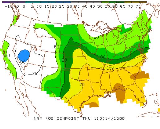
Tuesday will be the hottest and most humid day so far this summer...so get ready. It will be oppressive this afternoon. Dew points will be in the low 70s with a slight NW down sloping air that will compress and warm temps to the mid 90s in the Harrisburg area. Remember, we can have some rather hot days when the air down slopes off the mountains towards KMDT as the air warms adiabatically to the tune of 5.5ºF per 1000 feet of descent! So hot air "over the top" so to speak can lead to some rather hot conditions. The maps below show both the max highs for the country for Tuesday and the dew points:
Here are the dew points for the same time. Note the drier air to our NW and it's coming our way.
Here are the dew points for Wednesday afternoon. Much drier!
Here are the dew points progged for Thursday morning:
And here are the forecast for PA for Thursday morning with the map of morning lows. That will feel quite refreshing!
The weekend and points beyond look to be more of the same repetitive pattern. Although this weekend, I do believe there is a chance of a cloudy dreary weekend with a stiff onshore easterly wind that would lead to overcast skies and temps in the 70s.
As for precip, there is a chance of a stray storm this afternoon, but not a widespread event. In fact, most people will see nary a drop of rain through the remainder of the week. The rain will be kept to our south over the next week as the map below shows! This is the total precip through next Wednesday. That train of rain suggests an on shore flow from the Atlantic at our latitude. Just a thought....
In closing, the ongoing drought in the south-central and SW portion of the US is not expected to end any time soon. The NWS recently predicted that severe drought conditions will continue in Texas and Oklahoma through this year and into 2012. In order to escape the drought sooner, the region will need a few tropical systems to spread desperately needed rain to the area. The most recent US Drought Monitor report as shown below indicates that over 71% of the state is in the exceptional drought level, which is the worst drought level. The July 5 data can be seen below. New Mexico is marginally better(~41% exceptional drought) as is OK....where in terms of water at present, Oklahoma is not OK!
Enjoy your MLB all-star (sort of) game Tuesday evening....
Smitty
AA: Hot & humid Tuesday, warm and drier Wednesday, refreshing Thursday and Friday....might be a cloudy dreary weekend...might? Not sold on that one yet.....Go National League!